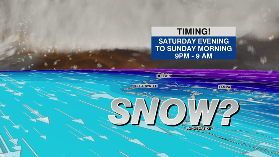
UPDATE: Meteorologists are urgently warning residents of the Tampa Bay Area about the possibility of snow flurries this weekend, an event that could be a once-in-a-generation occurrence. The prediction comes as a piece of the Polar Vortex breaks off and pushes south, leading to conditions conducive to Gulf Effect Snow.
This rare weather phenomenon is expected to begin affecting the region starting on February 3, 2024, with significant temperature drops forecasted. Residents are advised to prepare for an unusual winter experience in a typically warm climate.
Why This Matters: The potential for snow flurries is not just a meteorological curiosity; it could disrupt daily life, impact travel plans, and necessitate emergency preparations across the affected areas. As temperatures are predicted to plunge, officials are emphasizing the importance of staying informed and ready for unexpected conditions.
Meteorologists are monitoring this developing situation closely. According to forecasts, the cold snap could lead to temperatures dropping into the low 30s Fahrenheit (around 0 degrees Celsius) by the weekend. The possibility of snow flurries, while not guaranteed, is becoming increasingly likely—especially in coastal and inland areas.
What to Watch For: Residents should keep an eye on local weather updates. Meteorological authorities recommend checking forecasts regularly and staying prepared with winter supplies, such as blankets and food. Additionally, travelers should anticipate potential delays or cancellations as the winter weather approaches.
This extraordinary weather event serves as a stark reminder of the unpredictability of climate patterns. As the Tampa Bay Area braces for this unusual cold snap, the community is coming together to navigate the challenges posed by potential snow.
Stay tuned for further updates as this situation evolves and more detailed forecasts are released. Residents are encouraged to share their experiences on social media, making this a moment of collective memory for the Tampa Bay Area.