Strong Storms Return Tonight with Heavy Rain and Flood Concerns
Powerful showers and thunderstorms are moving into parts of the southern United States tonight, bringing the risk of large hail and damaging winds. According to the CBS 42 Weather Livestream Channel, a cold front drifting south combined with an upper-level disturbance will trigger this new round of storms mainly along and south of Interstate 20.
The severe threat is currently rated as a Marginal Risk (Level 1 out of 5), but residents should remain alert as frequent lightning, large hail, and damaging winds are possible. The storms are expected to bring 2 to 3 inches of rain by the time they move out, which will provide some drought relief but also increase the risk of localized flooding in vulnerable areas.
Temperatures Drop Tonight, Cooler Weather Ahead
Tonight’s lows will drop to the lower to mid-50s, offering a cool break from the recent warmer trend. The cold front will continue southward, pushing the rain out by Thursday morning as it heads toward the Gulf Coast. Thursday will be mostly dry with partly cloudy skies and high temperatures settling in the mid-70s. This brief respite will allow for some recovery before more unsettled weather arrives.
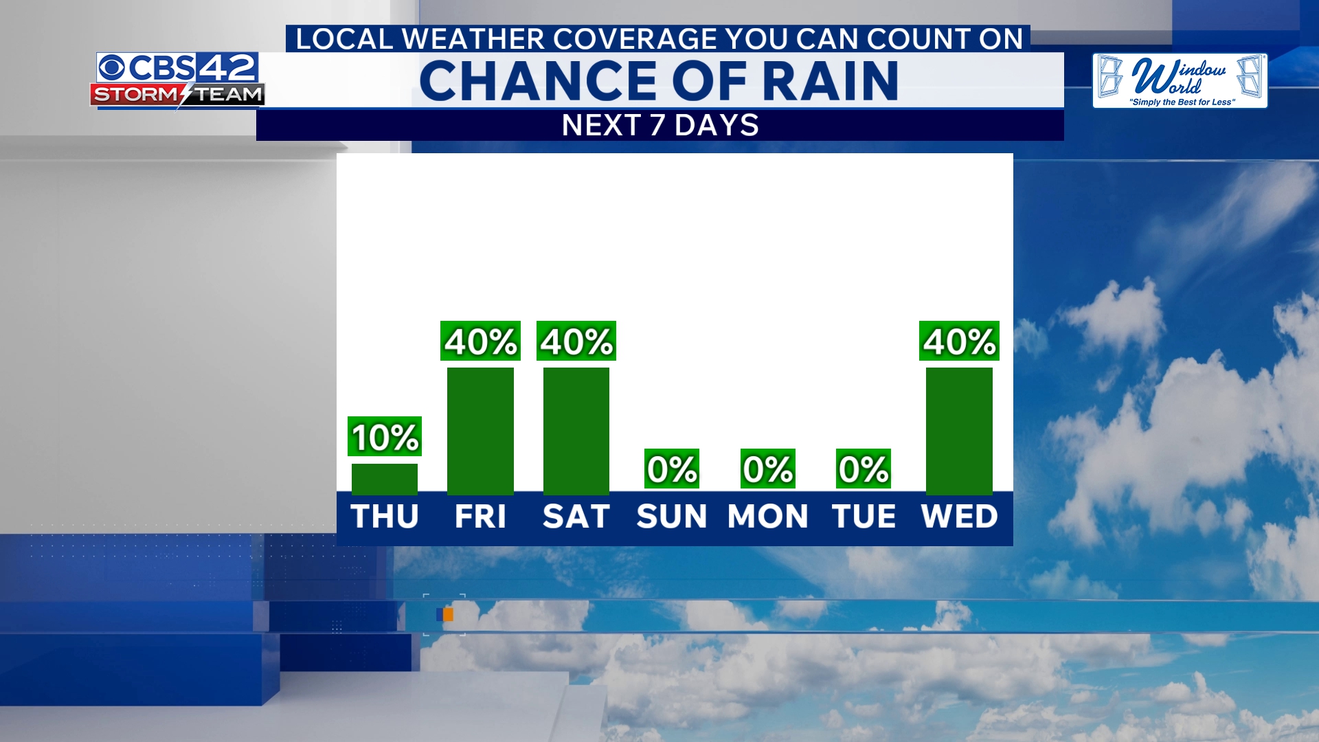
Friday Brings More Showers and Thunderstorms, Cooler Temperatures
The storm track intensifies again on Friday as a low-pressure system moves along a stalled coastal boundary, delivering scattered showers and isolated thunderstorms. Although these storms are expected to be non-severe, Friday’s highs will dip further to the upper 60s, contributing to a consistently cooler pattern for the end of the week.
The wet weather does not stop there: widespread rain and thunderstorms are forecast to pick up again late Friday night into early Saturday morning. Nighttime temperatures will fall to the upper 40s to around 50 degrees, setting a chilly tone for the weekend.
Weekend Outlook: Lingering Showers and Gradual Clearing
Showers may persist into Saturday morning but are expected to taper off in the afternoon as skies gradually clear. Saturday’s highs will remain cool in the upper 60s. Saturday night promises mostly clear and colder conditions with lows dipping into the 40s.
For Sunday, forecasts call for dry and sunny weather with pleasant highs again in the upper 60s, offering a much-needed break after several days of unsettled weather.
What Ohio Residents Need to Know
While the source locations center around areas south of I-20, these storm systems highlight the potential for shifting weather patterns impacting much of the eastern U.S., including Ohio. Rapid changes in temperature and periodic heavy rainfall could affect travel plans and outdoor activities across the state this week.
Residents are urged to monitor local weather updates and prepare for quick changes in conditions, especially during peak storm periods tonight and Friday night. The combination of heavy rain and gusty winds can create hazardous situations, including flash flooding in some areas.
“We expect the cold front and upper-level disturbance to spark a second round of storms with localized severe risks mainly south of I-20,” said a CBS 42 Weather meteorologist.
This developing weather pattern serves as a reminder to remain weather aware as the storm system moves eastward and continues to influence the U.S. Southeast through the weekend.
The Ohio Observer will continue monitoring storm developments and provide the latest updates to ensure the safety and preparedness of Ohioans and audiences nationwide.