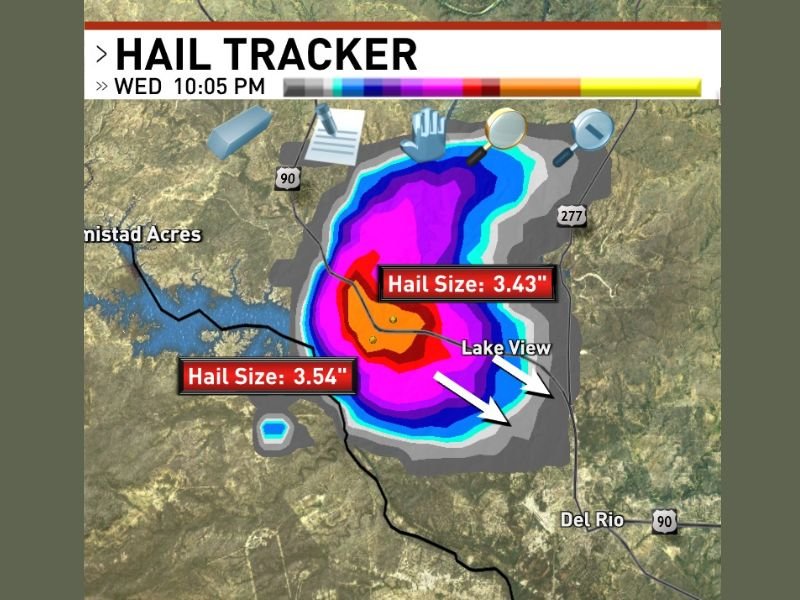
A devastating supercell thunderstorm ripped through Lake Amistad, Texas, on Wednesday night, producing giant hail stones measuring up to 3.54 inches in diameter, raising serious concerns for residents in the path of the storm. The 10:05 PM storm observation confirmed two giant hail size readings of 3.54 and 3.43 inches, placing this supercell among the most destructive hail producers amidst the ongoing severe weather outbreak across the southern Texas region.
Hail Tracker data revealed the storm’s most intense hail core was centered directly over Lake Amistad, highlighted by deep red and magenta radar returns that signal the concentrated zone of the largest hail within the supercell’s powerful updraft. Such hail sizes are catastrophic, capable of punching through vehicle roofs, shattering windshields, shredding roofs, and posing a direct life-threatening hazard to anyone caught outside.
Supercell Advances Southeast Toward Del Rio Corridor
The supercell’s forward motion southeast drove the destructive hailstorm toward populated communities, including Del Rio, Lake View, and Amistad Acres. At the time of the warning, these areas were directly in the storm’s path, placing hundreds of homes, vehicles, and residents at risk of major damage.
Hail Tracker visuals showed a broad swath of damaging hail extending beyond the immediate core, signaling that not only the largest giant hail, but also smaller, still destructive hailstones, were pounding a large geographic area. This intensifies concerns for widespread property damage and community safety along the storm’s corridor.
Additional Hail-Producing Supercell Adds to Severe Weather Impact
The Lake Amistad supercell was not an isolated event—at least one prior supercell had already cratered the region earlier Wednesday night with large hail, compounding damage and increasing risks to residents. The back-to-back occurrence of giant hail-producing storms signals an unusually volatile and destructive severe weather event striking southwest Texas this evening.
Local officials and weather services urge residents in the path to take every precaution immediately, emphasizing the extreme threat posed by near softball-sized hail. Vehicles, homes, and anyone caught outdoors face critical risk. Authorities continue to monitor the storm’s progression closely and are expected to update warnings as it moves farther southeast.
For ongoing, authoritative severe weather updates and detailed storm analysis, US readers can follow SaludaStandard-Sentinel.com and local weather alerts. While this event is focused far from Ohio, it underscores the type of severe weather outbreaks that can develop in warm-season storm zones nationwide, reminding Midwestern residents about the power of supercell storms and the critical need for awareness and preparation.
This violent hailstorm marks one of the largest hail events recorded so far during this severe weather outbreak and is a stark reminder of the devastating capability of supercells to produce giant hail in rapid succession. Stay tuned to The Ohio Observer for more updates as the situation develops across southern Texas and national severe weather watches.