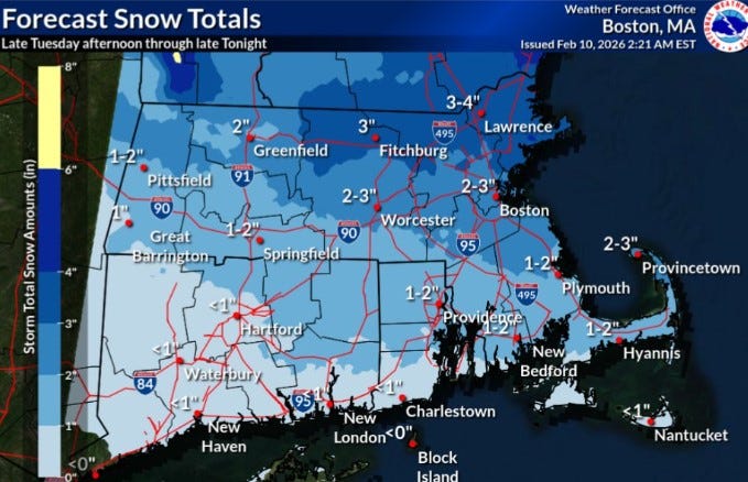
URGENT UPDATE: A fast-moving storm is set to impact Rhode Island this afternoon, bringing 1 to 2 inches of snow to the state. The National Weather Service confirms that snow will begin falling later today, February 10, 2025, and could continue into the night. Residents should prepare for slippery conditions on the roads as snow accumulates throughout the evening.
The northern two-thirds of Rhode Island will experience the bulk of the snowfall, while the southern part is expected to see a mix of rain and less than 1 inch of snow. In contrast, parts of Massachusetts, particularly in the northeast, could receive between 3 to 4 inches of snow from this system.
Despite this storm not being a major snow producer, it will contribute to existing snow totals in Rhode Island, where more than 20 inches has already fallen in January alone. An additional 2.6 inches has been reported so far in February, leaving Providence with approximately 10 inches of snow still on the ground. This persistent snowpack has occurred amid frigid temperatures, with February averaging 19.9 degrees, significantly colder than the normal for this time of year.
The extreme cold is expected to ease this week, with highs forecasted to reach 34 degrees in Providence today. Temperatures are projected to remain mild, ranging from 35 to 36 degrees through Saturday, February 15, 2025. However, forecasters are already monitoring another potential coastal storm that could affect the region this weekend, which may bring more snow.
Residents are urged to stay informed as conditions develop and to remain cautious on the roads during this winter weather event. Authorities recommend checking local forecasts and the National Weather Service updates for the latest information.
Stay tuned for further updates as the situation unfolds.