TULSA, OKLAHOMA — A powerful severe storm complex is advancing rapidly toward the Tulsa metro area with expected arrival within hours as of 10:15 PM, bringing threats of damaging winds, very heavy rain, and a possible spin-up tornado.
Forecasters warn all residents in Tulsa and surrounding communities to seek immediate shelter and stay indoors until the system passes. Intense radar signatures show the storm’s primary cells pushing from the west and northwest directly into Tulsa and nearby suburbs including Skiatook and Sapulpa. Additional storm tracks extend north toward Bartlesville and surrounding areas in Washington County.
Damaging Winds, Flooding, and Tornado Risk Top Concerns
The main threat arises from damaging winds capable of downing trees, power lines, and causing substantial structural damage across the Tulsa metro region. Heavy rainfall is also expected to trigger sudden water accumulation on streets and in low-lying zones, creating flash flooding dangers.
While not the immediate focus, meteorologists emphasize that the risk of a spin-up tornado remains real within this storm complex. This means Tulsa residents should treat the event as potentially tornado-producing and take shelter in interior rooms on the lowest floors of sturdy buildings without delay.
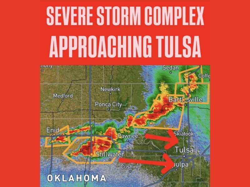
Storm Track and Impacted Communities
The complex currently stretches from near Enid eastward through Pawnee, extending toward Skiatook and northern Tulsa suburbs. Radar highlights two distinct warning polygons for separate storm cells moving eastward. One is directly targeting Tulsa proper, while a second cell is advancing toward Sapulpa just south of Tulsa.
Communities north of Tulsa, such as Bartlesville and adjacent Washington County areas, are also under active warnings as a northern segment of the storm moves through. Towns including Stillwater, Pawnee, and Cushing have already experienced severe weather and continue to face dangerous conditions as the overall complex pushes eastward.
Immediate Safety Steps for Tulsa Residents
Authorities urge all Tulsa metro residents to move to an interior shelter immediately—do not wait for visible signs of the storm’s arrival. Stay clear of windows, avoid travel especially across flooded or water-covered roadways, and continuously monitor local weather broadcasts and alert systems for updates or tornado warnings.
“All residents should treat this as a potential tornado-producing event and seek interior shelter on the lowest floor of a sturdy building immediately.”
This severe system poses a serious threat to life and property tonight. Preparedness and swift action can reduce risks as the storm complex barrels eastward.
Residents tracking this developing weather threat can expect updates from local meteorological services, emergency management agencies, and news outlets across Oklahoma and neighboring states. Stay informed and stay safe as this storm unfolds.
The Ohio Observer will continue to monitor the latest on this severe weather event impacting the midwest region and provide timely news and safety guidance as the situation develops.